 Home
Home  Navigation


スーパー地形 - GPS対応地形図アプリ
Category:Maps & Navigation Size:16.7 MB Version:4.6.17
Developer:kashmir3d Rate:3.3 Update:May 08,2025
 Application Description
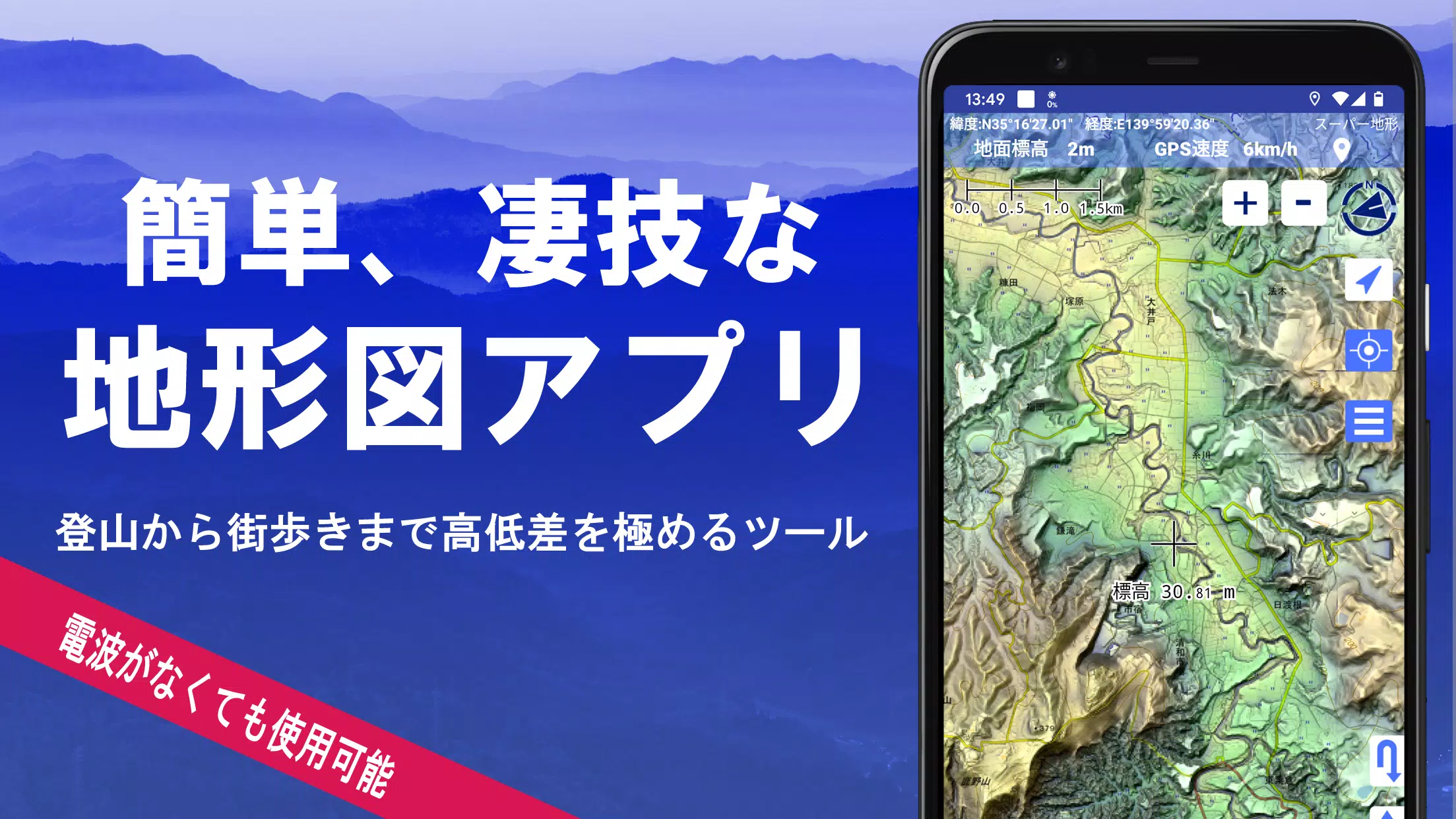
Discover the versatility of over 100 types of maps available for your adventures, from mountain climbing to leisurely strolls around town. With the inclusion of maps from the Geographical Survey Institute, you can leverage detailed terrain data to enhance your exploration experience. The app received the prestigious 2018 Japan Cartographic Society Award for Best Work, a testament to its excellence in mapping technology.
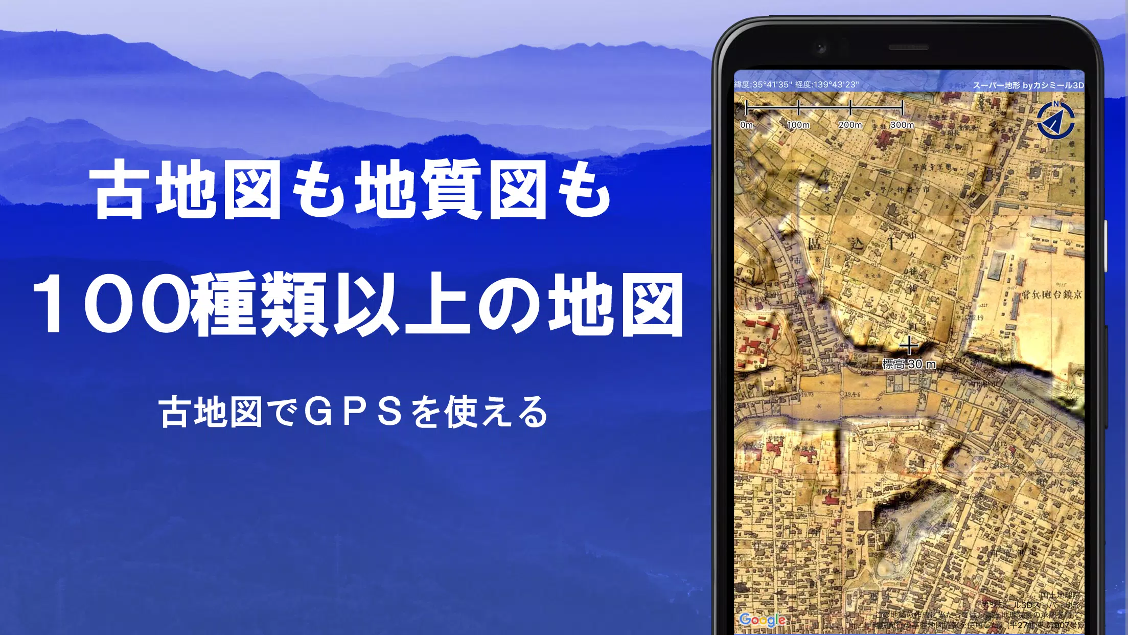
Utilize "super terrain data" that highlights terrain through unique technology, alongside a variety of maps from the Geospatial Information Authority of Japan. These include topographic maps, geological maps, historical maps, and even prewar Ordnance Survey Department maps. Record your tracks using the GPS function, and take advantage of GPX log input/output and editing capabilities for a personalized experience.
The app is equipped with features tailored for urban navigation, mountain climbing, and outdoor activities, including GPS navigation with audio cues and data recording/editing functions. Enhance your planning with the visibility determination feature, useful for creating cross-sectional diagrams, observing landscapes, and assessing radio visibility. You can also visualize buildings within your maps.
Explore with the 360° panoramic view function, which aids in mountain identification, displaying mountain names, sun, moon, and GPS points. Enjoy offline capabilities with bulk map downloads and map caching, perfect for climbing or outdoor adventures without signal coverage. Associate photos with specific points, display contour lines generated from elevation data, and utilize the MGRS grid for precise navigation.
The app supports GIS data from GeoJSON files, enabling you to read, display, and edit geographic data. Draw shapes, use the app overseas, and enjoy map printing and PDF output functionalities. A dark theme is also available for comfortable viewing in various lighting conditions.
A Wealth of Maps That Can Be Used
Choose from over 100 types of maps, including combinations of our proprietary super topographic data and maps from the Geospatial Information Authority of Japan. Note that aerial photographs vary by age, with "latest" and "around 1974" offering broader coverage. Super terrain data maps are free to use for the first 5 days after installation.
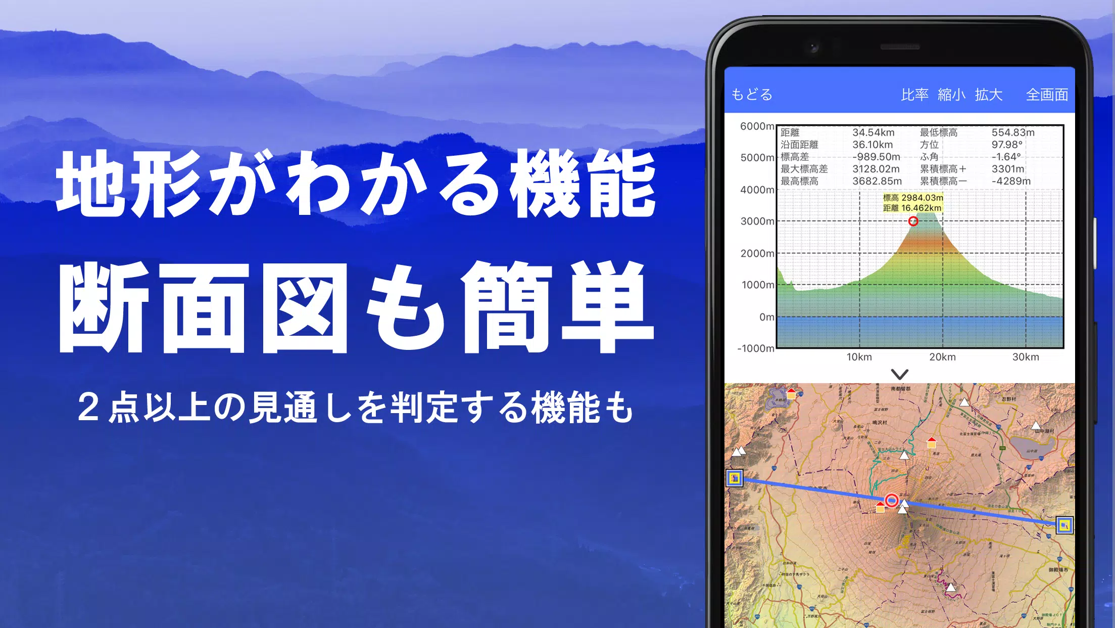
Creation of Cross Sections and Outlooks
Effortlessly draw cross sections through any point on the map, and benefit from the visibility judgment function, which accounts for the Earth's curvature and atmospheric differences. This feature is invaluable for route planning during climbs, assessing wireless visibility, and understanding terrain. Where PLATEAU building data is available, you can include buildings in your cross-sectional views.
Elevation Palette Function
Customize your map's appearance with the elevation palette function, allowing you to change the background color and create a gradient effect in 1cm increments according to your preference.
Panoramic View
Experience panoramic observation maps that display mountain names from any point on the map. The 360-degree panorama links with your smartphone's compass for accurate mountain identification. You can also view the sun and moon, including moon phases, useful for spotting Diamond Fuji and Pearl Fuji, and check the location of GPS points. Extend your exploration with panoramic views of mountains abroad.
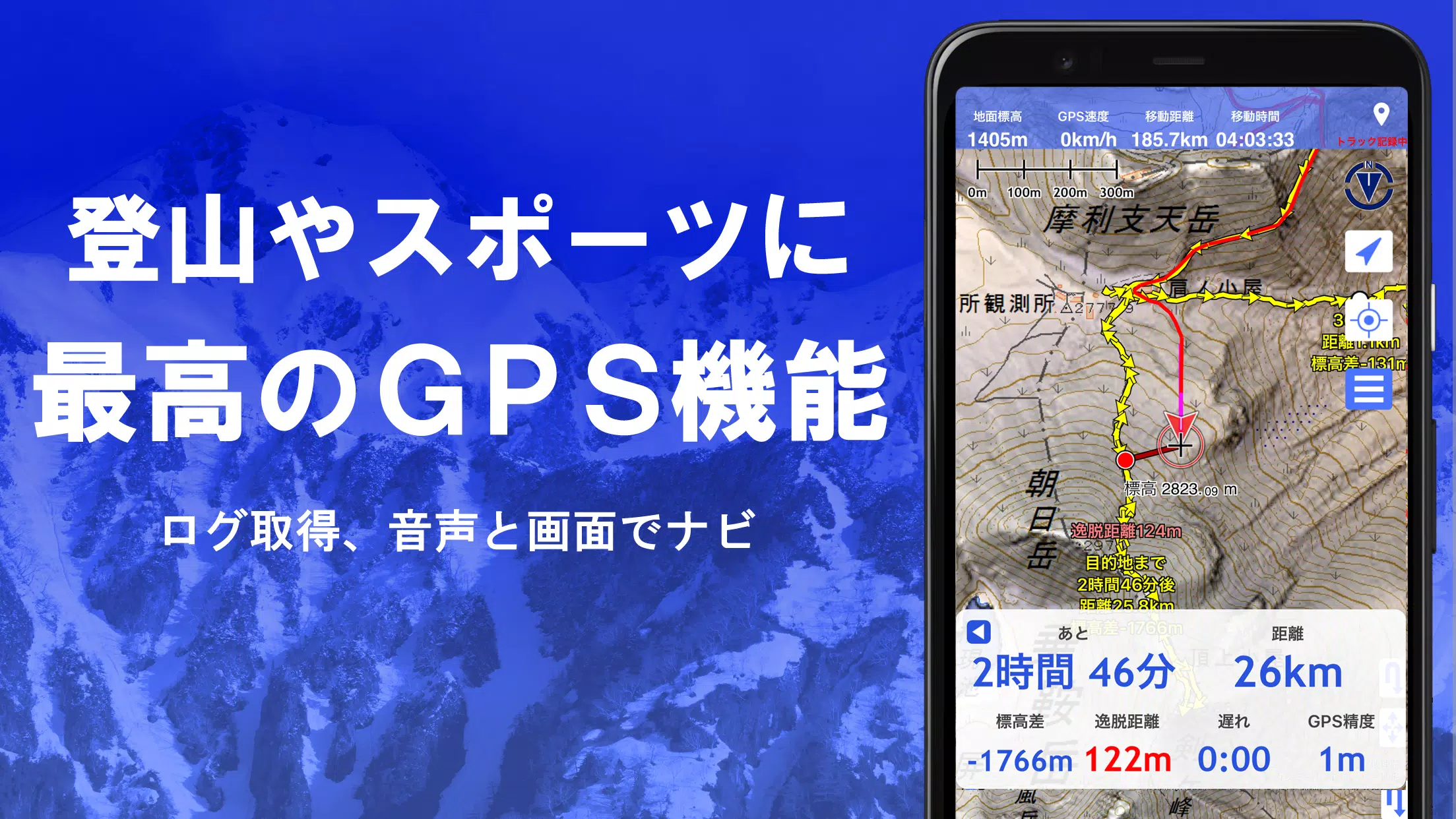
GPS Function
Leverage your smartphone's GPS to obtain location data and record tracks with high-precision measurements suitable for serious mountain climbing and outdoor activities. Visualize your recorded tracks with parameters like elevation gain, speed, time, and elapsed time. The point alarm function alerts you with voice and sound when approaching specified points. Display photos associated with these points and send the map center position to NaviCon.
GPS Track Summary Playback
Replay your recorded tracks effortlessly, with the app matching and displaying photos taken during your journey based on their timestamps. Icons indicate photo locations, accessible with a simple tap.
GPS Navigation Function
Navigate preset tracks using the Track Navi feature, which alerts you with voice or sound if you deviate from the path, ensuring you stay on course during climbs. Additionally, benefit from route navigation for urban walks and point navigation to reach specific locations.
GPS Data Editing Function
Manage GPS-related point, route, and track data in an easy-to-read tree format, organized by folders. Create tracks directly on the map, and import/export data in GPX format from various mountain climbing sites.
Map Usage Outside the Service Area (Offline)
Continue using maps even in areas without signal, such as during mountain climbs, thanks to the bulk download function that allows you to download all scale maps of a specified area. Monitor your downloads to ensure you have the necessary maps on site. A cache function is also available for offline use.
Map History Function
The app remembers your viewed locations, allowing you to return to previous spots easily.
Custom Map Compatible
Import and use custom maps created with Kashmir 3D's map cutter, including your own maps and scanned images. When using the map cutter, divide images into approximately 256 x 256 pixels and send the resulting kmz file to Super Terrain via email or Cloud Drive.
GeoJSON Compatible
Display and edit points, linestrings, and polygons from GeoJSON format files, and draw new shapes as needed.
Print/PDF Output
Print any map area at a specified scale or generate a PDF for your records.
Cooperation with Other Apps
Exchange GPS data in GPX, KML, and GDB formats with other apps, including the PC software "Kashmir 3D," and utilize trajectory data from mountain climbing sites.
Backup Function
Back up all app data (excluding cached maps) and remove it from your smartphone. Restore your data even if you delete the app or experience a device malfunction. An automatic backup feature using Google Drive ensures your data is always up to date. Refer to the manual for detailed instructions.
About Billing Function
Some features, such as maps using super terrain data, GPS track functions, and cross-sectional views, require in-app purchases. After payment, the number of search results for place name searches increases.
●Fees
Annual payment: 780 yen/year
●Free Trial
Enjoy a 5-day free trial upon first installation. After 5 days, some features and maps will be unavailable unless you make a purchase. You will not be charged unless you initiate a purchase within the app under [Settings] - [Purchase to remove functional restrictions].
●Confirmation and Cancellation
Check or cancel automatic updates by:
- Opening Google Play
- Selecting "Regular Purchase" from the menu
- Choosing "Super Terrain"
●Price Revision
Prices may change due to future enhancements. Early purchase is advantageous.
Terms of Use
The copyright holder and developer are not responsible for the outcomes of using this application. Upon first use of GPS, you will be prompted to allow location services. Continuous GPS use may drain your battery, so carry a spare if your device is used for emergency communication.
For a detailed explanation of the navigation function, refer to the PDF at https://www.kashmir3d.com/online/superdemapp/superdem_navi.pdf.
Note that some smartphones may interrupt or fail to record tracks due to power-saving features that close background apps. While turning off the screen may temporarily maintain recording, this is not a permanent solution.
Screenshot
 Reviews
Post Comments
Apps like スーパー地形 - GPS対応地形図アプリ
Reviews
Post Comments
Apps like スーパー地形 - GPS対応地形図アプリ
-
 Speed Camera DetectorDownload
3.2.31 / 91.7 MB
-
 Hopp DriverDownload
DA.94.1 / 45.0 MB
-
 Taxi ToulouseDownload
4.0.2 / 27.9 MB
-
 Yassir - Ride, Eat & ShopDownload
3.17.1 / 122.6 MB
Latest Articles
-

Puella Magi Madoka Magica Magia Exedra celebrates its anniversary with an all-new story event, Memories of You Part II, alongside a demanding limited-time Tower battle mode, both now live in the game.A Deeper Look at Madoka and Homura's ConnectionThe
Author : Lily View All
-
Best Live Sports Streaming Sites for 2025 May 09,2026

Watching live sports was once straightforward—just turn on your TV, and the big game was usually available. Today, sports streaming has become increasingly complex, with regional restrictions, additional subscription barriers, and exclusive broadcast
Author : Aria View All
-
Sovl: Fantasy Warfare Launches on iOS May 07,2026
Sovl: Fantasy Warfare is now available on iOSIt blends digital strategy with a ruleset designed for real-world miniature gameplayDive into a roguelite campaign, battle AI opponents, or challenge others in multiplayerThe world of tabletop fantasy warg
Author : Nova View All
Topics

Discover the best online shopping apps for seamless and convenient shopping experiences. This comprehensive review explores top-rated apps like ALDI SÜD Angebote & Prospekte for grocery deals, UNIQLO CA and UNIQLO MY for fashion, dahaboo for diverse products, FINN.no for Norwegian classifieds, Esdemarca for Spanish deals, Route for package tracking, Clicks for South African pharmacy needs, Carrefour Italia for Italian groceries, and B&H Photo Video for electronics. Find the perfect app to simplify your online shopping journey!


 Latest Apps
-
 Biedronka - Shakeomat, gazetki
Shopping 2.10.1 / 14.80M
-
News & Magazines 1.1.0 / 19.50M
-
News & Magazines 1.1 / 3.80M
-
News & Magazines 0.8 / 11.80M
-
News & Magazines 10 / 52.50M


 Trending apps


 Top News


- MCU Role Yet to be Cast for Jon Hamm Nov 12,2024
- Silent Hill 2 Remake Devs Want to Prove That They've Evolved Nov 10,2024
- Dragon Pow teams up with hit anime Miss Kobayashi's Dragon Maid for new collab event Nov 02,2021
- Unreal Engine 6: Building a Unified Metaverse Dec 10,2024
- Sonic Fan-Made Game Has Serious Sonic Mania Vibes Jan 08,2025
- Stellar Blade Heats Up with Summer Update Aug 23,2023
- New Update Restores Helldivers 2, Halting Decline Nov 09,2024
- Roia Is the Latest Tranquil Mobile Game from Award-Winning Indie Studio Emoak Nov 12,2024